Tuesday, February 15, 2011

McMurdo Station Arrival

   I've now made it down to McMurdo Station, one of the United States Antarctic bases.  The flight was so interesting.  We took an older C17 Airforce cargo plane that has been adapted to hold a lot of passengers.  Boarding procedures were still suprisingly similar to other airplanes except that we were required to be dressed in our issued ECW gear (Extreme Cold Weather).  The interior is still very much a cargo plane and many of the mechanisms are visible.  When boarding we were all given ear plugs due to how loud the plane would be.  There were several rows of normal forwarding facing seats near the front followed by a middle section of seats against the wall facing the interior and two rows along the middle of the plane facing the exterior.  In the rear of the plane were more normal forward facing seats.  During most of the flight, everyone was more free to get up and move throughout the cargo hold.  There were only small port windows on the exits, but you could freely get up and glance through them.  At one point, I touched some metal near the window and found it was freezing as there was little insulation between it and the exterior of the plane.
Inside the C17

Antarctic Mountains through the rear starboard view port of the C17
   We touched down on a sea ice runway at about 3:00 pm New Zealand time on Monday the 14th (8:00 pm Sunday the 13th Central time) to what we were told was -11 degrees.  It certainly didn't feel that cold.  Perhaps they were telling us degrees Celsius.  It was still freezing of course; about 12 degrees Farenheit.  I was glad to be wearing the ECW gear already.  Upon leaving the plane the scene was absolutely breath taking.  We were surrounded in every direction by miles mostly flat white sea ice fields framed in all directions by distant mountains shrouded in white but streaked slightly with gray far out on the horizon.  We were hurried along into large orange all terrain vehicles that could have driven over any terrain in its path.  Along the bumpy 30 min. ride to McMurdo station, nestled on the edge of Ross Island in the Ross sea, we saw almost immediately our first penquins just sitting right off the flagged ice road.  Perfect views of the nearby active smoking volcano, Mt. Erebus, could be seen the entirety of the ride.
Myself, the ECW gear, and the C17 plane on the sea ice runway
Transport vehicles with a smoking Mt. Erebus in the background


   McMurdo is situated on the edge of the island in a very interesting self contained village that houses upwards of 1,000 people at times.  Large supporting structures can be seen every where such as giant white cylindrical fuel tanks on the outskirts of the so called "Mactown"; a stark contrast to the dark volcanic dust and scree upon which the town sits.

   After the usual tours, briefings, and orientations we got our first taste of the cafeteria, which is just awesome.  Lots of choices and many of them healthy.  After that, many of us proceeded up the very near mini-mountain, obs point, a very steep small mountain made up of all volcanic ash and scree (though not volcanic itself).  It was a a tough but short climb, and the sites from there were absolutely amazing even at a very sunny 10:00 at night.  The sun does not set at all right now.  I've seen similar in Alaska during my mountaineering class, but at least there it dipped below the horizon for an hour or so in a soft twilight light.  Here it merely dips from its circular path around the horizon but never falls below it.
Obs. Point

McMurco looking down from Obs. Point

   Unfortunately our brief week in Antarctica puts us into a temporary housing dorm that is referred to as "the man camp".  It is a single long room with 12 bunks in it housing up to 24 in one room with very little room for baggage (all of us have 2 or more medium to large bags). It will be an interesting arrangement until the Palmer (research vessel) arrives and we can move into our staterooms on the 17th, followed by two or more days of loading and setup of instruments, computers, and work and analysis stations.  Nonetheless, it is incredible to be here on a continent that few visit and many don't ever care to.  Such an extreme environment.
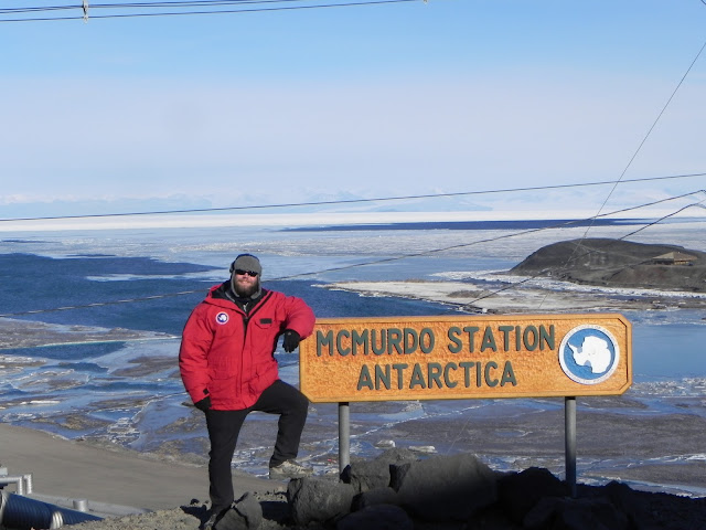
The station sign with an ice pier for the ship and the ill fated explorer Robert F. Scott's original 1902 hut in the background (both right side of photo)

Christchurch, New Zealand

  Our flight down to McMurdo station was scheduled out of Christchurch, New Zealand, one of the major support points for Antarctic operations.  I flew down to New Zealand a week ahead of time to spend a little vacation time there.  During my vacation time, I went for a couple of hikes through both the mountains and down the beach, visited an Early Antarctic Expedition photo exhibition at the local art museum, toured the local Botanical Gardens, and took a harbor cruise to see endemic endangered dolphins as well as sampled a delightful array of foods and spent time hanging out with a small group of multi-national European travelers.
The city's namesake, in the central downtown Cathedral Square

  During my set of flights to New Zealand, I met a fellow physical oceanography student, Eric, from Florida State who ended up being a welcome travel companion in a foreign (but English speaking) place.  I surprised him in a humorous manner when I noticed his Florida State sweatshirt and that he was holding a book about Ernest Shackleton's Antarctic expedition, a famous but disastrous one, and I approached him and asked if his name was Eric?   I had remembered his name from the endless list of info emails we've been receiving since November.  
Eric on the mountain hike over looking Christchurch

  The first full day there, we hiked through a small set of mountains just south of Christchurch.  The island is volcanic in origin and has mountainous features almost everywhere outside of the city.  We first hiked up a very steep grassy mountain, then followed a ridge line along the top through an enclosed vegetation corridor butted up against rocky bluffs and then through a ridge top World War 2 anti-aircraft battery strewn with sheep, then down off the mountain to a small harbor town called Lyttleton.  The hike had incredible views, but the thing that caught my awe the most was just how different everything was.  Aside from the dirt, rocks, and generic grass, everything was very different.  The plants looked entirely different aside from a few oak like trees, and the bird calls and insect noises were entirely foreign with different patterns and pitches.  The following day, was a rainy one, so we walked through the cities Botanical Gardens and again the difference was entirely noticeable.  Although in the confines of the Gardens, trees were allowed to grow to massive height and size, almost giant sequoia or giant redwood size.  The giant gnarled Eucalyptus trees were quite a sight.
Interesting bird I don't know the name of
Eric along the volcanic bluffs before venturing down into the vegetation corridor.  Lyttleton harbor in the background.

Vegetation Corridor on the hike

Sheep strewn about the anti-aircraft battery

sheep on the hillside over looking the entrance to Lyttleton harbor and the Pacific
Interesting and very different looking tree in the Botanical Gardens
Me standing next to a giant Eucalyptus tree
View from the beach hike

   The harbor tour was also from the town of Lyttleton and while it showcased the harbor's beauty set in between the mountains against volcanic bluffs and out to the open Pacific Ocean, the main attraction of the cruise was to catch a glimpse of the Hector Dolphin, an specialized dolphin local only to the harbors of the southern island of New Zealand.  We did see them, but only for a few minutes of intermittent surfacings.  Still the harbor cruise was worth it, although I lost a red hat that I like lot to the wind and the harbor waters.
Bluffs in Lyttleton Harbor from the tour boat

Hector Dolphins, very hard to photograph so this is the best I have

New Zealand flag with bluffs

   I very much like the New Zealand way of life.  It is a very laid back and friendly one that is entirely welcoming.  Perhaps this is due to the majority of their industry is tourism, but I just like to think it is the Kiwi way of life.  Christchurch itself may not be entirely the New Zealand way either since it is very multi-cultural throughout, but I enjoyed it immensely.   

   I am keeping the New Zealand post here to a minimum since A. the main part of the travelogue is about the Antarctic trip and the ocean voyage, and B. it was my vacation time.  But I've posted several pictures here to demonstrate my time there.
Statue of the ill fated Antarctic Explorer Robert F. Scott who was the second person to reach the South Pole

Intro

   First I would like to begin with a bit about the research cruise, then a bit about the science, and then a little bit about myself and why I'm going.

   The CLIVAR (climate variability) program has been an important ongoing research since the 1980's to study and attempt to understand the processes involved in creating, maintaining, and/or changing the earth's climate.  It's goal is to have repeating lines of measurement through decades of time.  The Earth's poles play a huge role in driving the climate system and distributing heat across Earth's surface.  This may seem a bit counter-intuitive, so let me explain.  Both atmosphere and oceans play a role, but I will focus on the ocean part.

   First of all, the polar regions for obvious reasons contain the coldest waters on the planet.  This means the water is condensed, as cold objects typically are, making the water heavier than water at other temperatures since there are more particles per volume as they are closer together.  Additionally, only fresh water goes into the formation of sea ice, so the salts originally dissolved in the sea water is left behind to dissolve into the surrounding waters.  Adding salt and making the water saltier adds the mass of the salt to the water, therefore making the water surrounding polar ice, which is very cold and very salty, the heaviest water on the planet.  This heaviest water then will sink and slip beneath other lighter less dense (mass per volume) waters (less salty warmer temperature).  As this occurs, the lighter water near the equator flows towards the poles to replace the heavy/densest sinking water while the denser waters ultimately will rise or "upwell" to the surface again due to other processes far away from the poles.  This creates a cyclical process that ultimately takes a very long time to complete (hundreds to thousands of years).  The cycle is important to climate in many ways with two notable ones described here.  The first is that dissolved carbon dioxide is pulled down with the sinking water thereby removing some of it from the atmosphere, however it is likely returned to the atmosphere a thousand years later when the water is returned to the surface.  The second is that warmer waters are cycled towards the poles thereby providing a means of delivering heat to the poles and temperate regions of the world allowing them to be warmer than they otherwise might be.  This is all of course a simplified view of what really happens.  The full process is quite complex and not fully understood, which is the purpose of this research cruise.


   The voyage will ultimately begin from the United States Antarctic base, McMurdo Station, aboard the National Science Foundation's icebreaking vessel, the Nathaniel B. Palmer.  From there we will traverse the Ross sea, named after Antarctic explorer James Clark Ross and home to the terminus of the world's largest continental ice sheet, the Ross ice shelf.  Then we will traverse the edge of the continent, heading east to the Antarctic peninsula and then heading across the Southern Ocean to Chile where we complete our voyage.  Throughout the cruise, we will be stopping at planned stations to take measurements of the ocean throughout the water column using oceanographic instrumentation.  Particularly we typically will drop a Conductivity, Temperature, Depth (CTD) instrument.  CTD's determine salinity by measuring conductivity, temperature directly, and depth from pressure whichs allows us to determine the density of the water and thus identify different masses of water.  After gathering many CTD casts throughout our cruise, it allows us to develop a picture of the types of water and their relation and movement through the region.  In addition to the CTD, we measure many different variables by a ring of bottles that are secured around the CTD on a metal cage.  The whole assembly is referred to as a Rosette.  A special cable allows us to close the bottles at different depths and capture water from that depth.  When the rosette is returned to the deck of the ship, we can then draw water samples from the bottles that can then be analyzed in different ways, such as checking for dissolved Carbon Dioxide or Oxygen levels or determining chemical composition.  Ultimately our collection of so many different variables gives us an idea of the state of the ocean there and the processes at work and we are able to compare them to previous research cruises to see how things have changed over time.
The CTD Rosette.  Bottles around the centered CTD.


   I am a physical oceanography student and I was chosen to go on this cruise almost solely on the basis of I was available and am a good candidate for gaining more field research experience.  My research actually has no relation to climate change, or to Antarctica.  Lucky me!  I may not have any research currently dealing with this, but I am very glad to be helping out and to be a part of something big in the oceanographic field.  Thanks for reading the first post, I promise that the rest will not be nearly as lengthy.  I expand on the science and travels in further posts.